Mapping and Distance Tools
Disclaimers, License & Copyrights
This program is free software; you can redistribute it and/or modify it under the terms of the GNU General Public License as published by the Free Software Foundation; either version 2 of the License, or (at your option) any later version.
This program is distributed in the hope that it will be useful, but WITHOUT ANY WARRANTY; without even the implied warranty of MERCHANTABILITY or FITNESS FOR A PARTICULAR PURPOSE. See the GNU General Public License for more details.
You should have received a copy of the GNU General Public License along with this program; if not, write to the Free Software Foundation, Inc., 51 Franklin Street, Fifth Floor, Boston, MA 02110-1301 USA., or visit one of the links here:
http://www.gnu.org/licenses/old-licenses/gpl-2.0.txt
http://www.acscdg.com/LICENSE.txt
Copyright 2006-2010 (c) Paul Demers <paul@acscdg.com>
This website is for educational and entertainment only. This application is not nearly accurate enough for real navigation or Earth measurements. Do not use for navigation or navigation planning.
Introduction
This application is an education tool that graphically illustrates great circles courses, and circles of equal distance on the Earth. A great circle is the shortest distance from one point on the Earth to another.
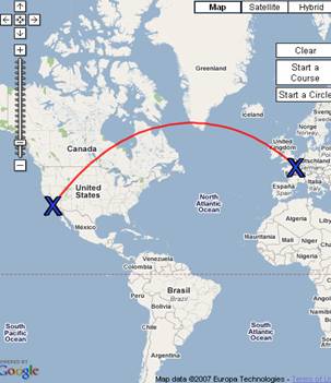
Figure 1 A Great Circle between Los Angeles and Paris
Great circles are approximated with a set of smaller lines. The smaller lines have constant course. A line of constant course is a rhumb line.
Long great circles appear curved. Long is more than about 600 nautical miles, approximately the distance between New York and Chicago. Courses that are close to straight north or south will not be curved. This is because lines of longitude are great circles, and north/south courses follow longitude lines.
Circles of equal distance enclosed all the places that are closer to a given distance to a point. For example, the circle below is all the places within 10 kilometers of the public gardens in Boston:
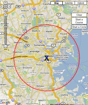
Figure 2: A circle 10KM around the public gardens in Boston
Finished circles have a smaller set of jagged lines inside them. The jagged lines make little arrows that point to the center of the circle. Very large circles look like very small circles on the other side of the world. The small circle is the points outside of the radius. That is, the circles get turned inside out. The little arrows are a reminder of where the center is, for example, the figure below is a circle 18,000 Km from Johannesburg.
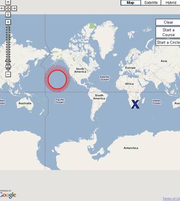
Figure 3: A circle 18,000 KM from Johannesburg
The inner lines only appear when the circle is finished. Drawing the inner circles is slow, and if drawn every time, it would be hard to make circles exactly the right size.
How to Draw a Great Circle Course
Click the button "Start a Course". Click on the map or use the find box to choose the starting point. Then, move the mouse over the map to the next point and click there, or use the fine box again. Points after the first are "way points", that is, points in between the first point and the last point. A blue letter "X" is drawn to mark each point. A temporary line is drawn as the mouse moves around. The line becomes permanent once the next point is selected. Click on "End at Last Point" to finish the course at the last point selected, or, "End at First Point", which adds one more line between the last point selected and the start point. Mistakes can be corrected by choosing the "Remove Last Point" button.
Clicking on a marker will add another point at the same location. Clicking on a location marker (see below) will add that point.
Multiple courses can be drawn on the same map by clicking the "Start a course" button again. Markers from previous courses can be selected to re-use the points.
How to Draw a Circle of Equal Distance
Click the button "Start a Circle". Click on the map to choose the center of the circle. Then, move the mouse away from the center to the desired point. A temporary circle is drawn to show the current circle, and the last row of the table is updated. The radius of the temporary circle is useful to know where to end the circle. Once the circle is the right distance, click the map again to finish the circle. Mistakes can be corrected with the "Erase Last" button.
Markers can also be clicked to choose the marker’s point.
Map Controls
The map has the standard Google map controls. The top right has buttons to switch between drawn maps and imagery, and the top left has controls to move, zoom in and out, and re-center. The map can be panned by dragging.
Changing Units
The distance units can be changed by selecting a new unit of measure in the pull down box. The choices are nautical miles, miles, and kilometers.
How to use the Place and Address Finder
Places and addresses can be found by typing into the place and address finder box, then clicking the "Find" button. A red push-pin marker is drawn for each place, and a description box is shown. The point is added to the current course, or used to define the circle while in drawing mode. Points can be added to courses by selecting the red push-pin markers. Some addresses will show an error, even though the address exists. This is a limitation of the public geocoder.
Example
Draw a line from Boston to Los Angeles:
- Click on the "Start a new Course" button.
- Type "Boston" into the find by address box, and hit find: The maps will re-center to Boston, and first point of the course will appear.
- Type "Los Angeles" in the find by address box. The map will re-center, and the second point will appear.
- Click the "End at Last Point" button.
Who Uses Great Circles?
Long haul airline flights generally follow great circles for the shortest path. However, there are many other considerations in flight planning, especially wind. There are also safety concerns, for example, two engine planes must stay within a reasonable distance of a usable airport.
Ships also follow great circles on long voyages. Ships also have other considerations, including shoals and ice.
Who Uses Equal Distance Circles?
Equal distance circles are used in flight planning, to estimate the range of an aircraft. The circles are adjusted for prevailing winds.
They are also used by urban planners, for example, find all the communities within a given distance of the city center.
There are also military users, for example where to place artillery or rocket launchers to be in range of the target, and out of range of the opposition’s weapons.
References
http://en.wikipedia.org/wiki/Great-circle_distance
The American Practical Navigator (Bowditch)
Other Uses for this Application
Some of the original code was written so I could figure out how far I run. I zoom way down, then follow my path, clicking on each turn.
What’s with the Unreadable JavaScript?
I used a JavaScript compressor to shrink the code. Smaller JavaScript downloads faster. The compressor is available here: http://www.dojotoolkit.org/reference-guide/shrinksafe/index.html
The uncompressed source code is available here: http://www.acscdg.com/source_html/src_index_html.html